Wednesday, February 29, 2012

Oceanography


 Highlights of Gary’s progress on the
Our Far South Expedition
February 29, 2012


So what have we learnt? 
Oceanography
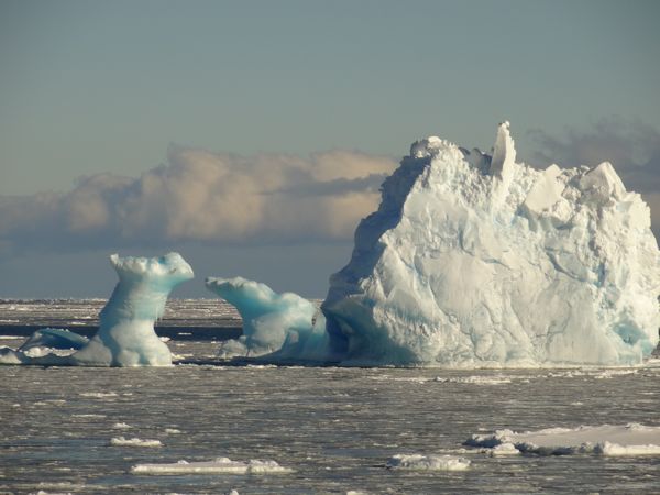
At 68° South, we have just crossed through the Antarctic Divergence and left most of the floating icebergs behind on our way north to Campbell Island. With a few days of steaming ahead, it is time to take stock and assess what we have learnt along the way. 

Oceanographically, this is a very unique part of the world. Because Antarctica is separated from all the other Southern Hemisphere continents by ocean, it allows a circum Antarctic ocean current to develop between the Antarctic Divergence and the Subantarctic Front buffering the Antarctic Continent from external influences. This current, known as the Antarctic Circumpolar Current or ACC washes along the southern margin of New Zealand’s subantarctic and then sweeps up past Dunedin to the Chatham Rise before heading east, which explains why Dunedin was witness to those ice-bergs a few years ago. The ACC effectively regulates temperatures at the southern end of New Zealand. Closer to Antarctica, and within the Antarctic Divergence, cold and saline water sinks to the ocean floor and also flows along the bottom of the ocean past the eastern seaboard of New Zealand, effectively driving global ocean circulation. Together, these two ocean currents form the main engine room of the global ocean system transferring heat around the planet and New Zealand’s subantarctic is in the firing line so to speak. 
So, what? Well the recent evidence is that Antarctica is warming up and with the melting and loss of ice shelves, a major concern is how will these major currents respond and what will be the effect on New Zealand? Changing temperature gradients across New Zealand? Different storm and rainfall patterns? A move in fishing grounds? Sea level rise? How much? How fast? It’s clear that our back yard does not end at Stewart Island, in fact one of the most significant part of the country is further south yet.

Coming up …. global warming and CO2

Tuesday, February 28, 2012

Ice


Highlights of Gary’s progress on the
Our Far South Expedition
February 27, 2012


Ice
Well we’ve now spent 3 days trying to get into places on the Mainland of Antarctica – Terra Nova Bay, Cape Hallet, Cape Adare… to no avail. Even though the Ross Sea itself is fairly open, sea ice and ice bergs are clustered along the bays and inlets along the northern Victoria Land coastline. We pushed through in several places but still did not manage to reach the coastline. Cape Adare was interesting as the current is about 2 knots and as we sat attempting to take samples, the floating ice was banking up against the ship. Needless to stay, we didn’t hang around. We’re now tracking east around the ice that has accumulated in the Ross Gyre and then tomorrow morning, it should be north to Campbell Island

Coming up….. So what have we learnt? 

Saturday, February 25, 2012

Historic Huts and the Ross Ice Shelf


Our Far South Expedition
February 25, 2012


Historic Huts
Ross Island is home to three historic huts from the Heroic Era of Antarctic exploration: Scott’s 1901 Discovery Expedition Hut at Hut Point, Shackleton’s 1907 Nimrod Expedition Hut at Cape Royds and Scott’s 1910 Terra Nova Hut Expedition Hut at Cape Evans. The Discovery Hut now lies in the shadow of McMurdo Station, but when constructed from an Australian kitset, it shared Winterquarters Bay only with the Discovery, which was moored nearby. The Hut itself proved too cold and difficult to heat for Scott’s men to live in it, so they used it mainly for stores and slept aboard the ship. 

Shackleton's Nimrod Hut at Cape Royds
In contrast, and 40 km to the north, Shackleton’s Hut at Cape Royds was home for 15 men. It was smaller with a large stove at one end and built in a hollow providing protection from the weather on all sides. This hut has recently been restored by the Antarctic Heritage Trust and should now withstand its next century on the flanks of Mount Erebus – sea level rise permitting. Only about 10 km to the south and across the Barne Glacier, the beach at Cape Evans is home to Scott’s Terra Nova Hut. Far larger and warmer than Discovery Hutt inside, but fairly exposed to the wind, as we discovered yesterday afternoon. Visiting the Hut is a dream for any Antarctic Geologist. To see the geologists quarters in the Hut and remember the feats of Frank Debenham, Edgeworth David, Raymond Priestley, and Griffith Taylor who all contributed to the mapping of the Dry Valleys and the Ice free areas of Victoria Land to the west of Ross Island.
Officers Table

Ross Ice Shelf
Ross Ice Shelf
Named the Ice Barrier in 1841 by Ross, when he found that he could not sail his ships Terror and Erebus further south, the leading edge of the Ross Shelf ends in a 30 m cliff. At 3.30 am, the light was not ideal, but for the first time I was able to see this great floating ice shelf in perspective. Stretching for hundreds of kilometers to the east, the ice cliff is the mere tip of the ice berg – the shelf is actually closer to 300 m thick, with much of it floating below sea level and in, on average, about 600 m of water. We saw the ice shelf from east of Cape Crozier, where the ANDRILL project are planning to use it as a floating platform to drill into the Eocene, 40 million year old, rocks on Coulman High to recover, amongst other things, a record of Antarctica in the high carbon dioxide greenhouse world. The drilling is only possible because of the ice shelf but the ice shelf also provides the biggest challenges for drilling. Ten years ago, a large ice berg broke off allowing a ship in to survey the sea floor and subsequently the ice has advanced back over the site at a kilometer a year, thereby re-establishing the platform for the drill rig over the site. But that 2.5-m a day ice advance limits the time that the drilling operation can continue before there is too much bend in the pipe. So, the technology will either have to enable us to drill faster than previous efforts or allow us to move the drill rig back along the ice shelf and then re-enter the drill hole and continue drilling deeper.
Ross Sea at midnight
Coming up….. the Antarctic Mainland


Thursday, February 23, 2012

Franklin Island and Scott Base


Highlights of Gary’s progress on the
Our Far South Expedition
February 23, 2012


Land Ho
Finally, after many days at sea, we anchored off the southern point of Franklin Island, where we made a rendezvous with the MV San Mateo which was in the Ross Sea carrying out some research on recruitment in the Toothfish fishery. We were also able to take a grab sample of the sea floor, while we were at anchor. Unfortunately, the bottom sediment is pretty coarse and we only managed to recover a sample of well-sorted volcanic pebbles – there’s obvious a fairly strong interaction with the bottom either from currents or large waves in a southerly blow. 

Before we left Franklin Island we were able to make a landing there despite the swell and breaking waves. There’s a large Adelle penguin colony on the Island but it was all but abandoned with only a few moulting birds remaining along with several sunbathing weddell seals. The evening saw the swell and wind drop away and glorious views of Ross Island from the north, as we tracked south and the sun set below Mount Morning. The colours of mounts Erebus and Discovery slowly changed from reds to orange to greens and we began to sea “grease” ice forming on the sea surface, which was formed into strange shapes as the ship pushed through it.

Hut Point Peninsula
Gary Wilson and Richard Levy at Scott Base
Hut Point is home to the United States McMurdo Station and New Zealand’s Scott Base. The sea ice has broken right out to McMurdo and at the moment the supply ship the MV Green Wave is tied up to the ice pier and offloading it’s annual resupply for the two research stations. Earlier the Fuel tanker had visited and restocked the fuel supply for the winter and next season. Staff from Scott Base met us and ferried us the 3 km “over the hill” to visit Scott Base – a first for many of the crew but a reunion with old friends for me as I was there only last December after undertaking fieldwork in the Skelton Neve. 

Scott Base is nearly in winter mode now with only a few of the Antarctica New Zealand staff remaining to fly north before the remaining crew settles in for the long Antarctic night and the task of repairs, servicing of vehicles and organizing of stores and supplies for the next field season which begins in a mere six months! Also in the winter crew are conservators from the Antarctic Heritage Trust who are preserving artifacts from the huts of Scott’s and Shackleton’s expeditions early last century. 

Our visit ashore concluded with a hike up Observation Hill where Scott’s men stood to look for his return across the ice shelf from his South Pole trek. Alas, he didn’t quite make it home and perished only 11 miles from one-ton depot, about a hundred miles from Ross Island. A cross stands atop observation hill erected to the men that never returned. It bears their names: Scott, Wilson, Oates, Bowers and Evans as well as a tribute, which reads “To Strive, to seek, to find, and not to yield”.

Coming up….. historic huts

Wednesday, February 22, 2012

The Ross Sea


Highlights of Gary’s progress on the
Our Far South Expedition
February 22, 2012


The Ross Sea
Our trek south in the Ross Sea began with picking our way through what looked like a minefield of ice bergs that sit at the entrance to the Ross Sea where they are corralled by the Ross Sea Gyre. An amazing arrange of bergs from large tabular forms to small “growlers” mostly submerged beneath the surface. The bridge had several spotters employed to pick our way through. And then as fast as the Bergs appeared they we’re gone and we were back into open water. We’ve now been steaming south in the Ross Sea for two days and still no land. 


The ride has had it’s moments – most of yesterday we punched into a large swell and a 50 knot headwind, which brought sheets of spray across the top of the ship and gave us a rollercoaster ride as we fell off the top off one wave and into the next oncoming wave. But still no land in sight – The Ross Sea is far larger than I had envisaged in my mind. We’ve been aboard and steaming for nearly a week now but the lack of exercise does not seem to bother me as I am using a lot of energy just trying to keep still.


Coming up….. land ho 

Sunday, February 19, 2012

Moving South East from Macquarie Island


Highlights of Gary’s progress on the
Our Far South Expedition
February 19, 2012


ANARE station
The Australian National Antarctic Research Expeditions (ANARE) has staffed a permanent station on the Island since 1948. Today, the station can house up to 40 people. Resupply is by ship twice a year. Macquarie has no wharf so crates are lowered onto an amphibious vehicle known as a lark, which motors into the shore and then drives up the beach to the station. Refueling takes place with a long floating fuel hose from the ship to the tanks on shore. The station houses research staff working on a range of tasks.


While visiting, we were lucky enough to see the weather balloon launch. Twice a day, at the same time around the world, weather balloons are launched to track temperature and pressure in the atmosphere and allow a global scale maps and weather forecast to be constructed. Macquarie is one of the few places to supply data from this far south in the Southern Hemisphere. The station also houses staff of the Tasmanian Parks and Wildlife Service who have responsibility for wildlife management on the island. At the moment they are part way through a very ambitious project to eradicate rabbits, rats and mice from the Island. 

Icebergs
Well we’ve tracked 400 nautical miles SE from Macquarie and as we approach the Antarctic Circle north of Cape Adare, we’re starting to see small armadas of icebergs. For the last three days, we have sailed through a low-pressure system and seen the swell direction move around from the SW to the SE, which has been a blessing because the SW swell was hitting the ship beam on and producing quite a roll (side-to-side motion) in the ship. It was bad enough that we changed course for a short while one dinner -time to help keep the food on the plates! Tomorrow morning we should be past Cape Adare and turning south in to the Ross Sea.

Coming up….. the freezing ocean

Wednesday, February 15, 2012

Heading further south

Highlights of Gary’s progress on the 
Our Far South Expedition
February 15, 2012
Port Ross & Enderby Island
We awoke to find ourselves at anchor off Enderby Island in Port Ross. Today was a busy one, while most of the crew went ashore, we set up the sea floor sampling equipment and recovered some grab samples of the sea floor. Mostly sand, which is not surprising given that we were sitting offshore Sandy Bay. We also set up the corer but didn’t manage to recover any core in the loose sand. After lunch we took a zodiac across to Rose Island where we deployed a hydrophone for Trudi Webster. The hydrophone will sit there recording for the next six months, n which time, it will hopefully record the return of the Southern Wright Whale for their next breeding season. Trudi plans to recover the hydrophone from Polaris in its upcoming winter voyage to the Auckland Islands. With work complete by about 2pm we were then able to go ashore and have a look around Enderby Island. Ashore we met Louise Chilvers who has spent the summer carrying our the sea lion monitoring programme and then set a brisk pace for the 8km walk around the Island. We saw plenty of nesting shags and several seals with rather large shark bite sized scars in their sides. But the most memorable image in my mind is the beautiful red of the flowering Rata.

Carnley Harbour
Over night, the ship transited to Carnley Harbour which is in the southern part of the Auckland Is. The Harbour sits between the main Auckland Island and Adams Island to the south. The ship anchored off Raynal Point, close to the still visible wreck of the Grafton, where we managed to retrieve several grab samples of mud and a short core of mud and shell horizons using the piston corer.
Macquarie Island
Wow – what a different place. Macquarie is a relatively young Island that came out of the sea only 600,000 years ago. Geologically the Island is a segment of the ocean crust that has been exhumed at the southern end of the plate boundary between Australia and New Zealand. Macquarie is an Australian nature reserve administered by the Tasmanian Parks Service. We were able to go ashore at Sandy Bay, which is on the more sheltered eastern side of the island. Sandy Bay is home to a King Penguin and a Royal Penguin colony. We were also lucky enough to see Elephant Seals fighting on the Beach and a few Orca swimming offshore. Early this morning we were able to take a sea floor sample from Buckles Bay while we waited for the Parks Rangers to come aboard and be our guides for the day. At this point we are well into the Antarctic Circumpolar Current but the ocean conditions around the island are clearly very rough and we were only able to collect sand in the grab sampler. But the most stunning part of the visit here was my first sighting of the Aurora Australis at 1 am when we arrived and set anchor last night.


Coming up….. the ANARE station at Macquarie and then down wind to the Ice Edge

Tuesday, February 14, 2012

OurFarSouth Expedition - Prof Gary Wilson joins the crew

Kia ora, welcome to the New Zealand Marine Studies Centre Blog. Over the next week join us as we travel to the southern waters of New Zealand with the crew from the Our Far South - Beyond Stewart Island project.
The objective of this project is to raise New Zealanders’ awareness of the importance of the area between Stewart Island and the South Pole.

Our Far South Expedition
One of the key aims of the Our Far South expedition is to bring the region to the attention of New Zealanders and help develop a better appreciation of New Zealand’s connections to the region and indeed as far south as the Ross Dependency in the Antarctic. Professor Gary Wilson, who heads Otago University’s Marine Science Department, is sailing as a scientist on the expedition and is collecting marine sediment samples and cores from the ship with aim of defining the sediment characteristics associated with the different currents, water masses and fronts south of New Zealand and then applying the knowledge longer term records to track the change with time. He is only aiming to take discrete samples and short cores on this expedition and then target areas to collect longer record in future trips.

Highlights of Gary’s progress on the 
OurFarSouth Expedition
February 14, 2012


The pack-up and preparation
What a marathon getting ready to go. Not only did we need to have all the equipment all packed into transportable boxes, but we need to take our own fridges and freezers for storing samples. Thankfully Bob got most of this ready and packed up while I focused my attention on permits for sample collection from each of the marine reserves along the way. The New Zealand Subantarctic Islands are administered by the Department of Conservation Southern Islands Office, Macquarie by the Tasmanian Parks Service and the Ross Sea by the Ministry of Foreign Affairs and Trade and the Ministry of Fisheries. Last but not least we also need permits to import the samples from Biosecurity NZ. So plenty of different agencies to deal with.

Loading
Six am departure from Dunedin to get to Bluff in time to start loading at 10am. The loading to about 4 hours by the time we worked out where we could stow and tie down all the equipment. It was out first attempt to communicate with the Russian Crew. Fortunately the sign language for driving cranes and winches is universal so even though we didn’t have a word in common, a quick point followed by a hand gesture made light work of the job once we got going. Then it was back to Invercargill to meet our fellow crew and get some last minute supplies, including collecting the passport that had been couriered down to me. Who’d have thought to bring it, not me! Still I guess we are actually visiting Macquarie Island enroute to the Antarctic which means we are officially entering Australia.


The Snares
The Snares Islands have one of the highest levels of conservation status so we didn’t get to go ashore. And the water around the Snares is too deep to anchor so the ship stood off while we had a close up look from Zodiacs. We were able to go into the small bays and even traverse through a few of the many Caves and passages between the Islands. The Snares themselves are granite, similar to that on Stewart Island and the southern ocean has managed to wear away at the many joints and cracks in the rock to form the caves and passages. By a curious twist of fate, maybe because they are relatively inhospitable in the first place, the Islands have managed to avoid introduced rodents, thus they are a haven for seabird life. A highlight was seeing the Snares Crested Penguins clinging to the steep rocky margins of the Islands. They are endemic and nest up in the stunted forest on the tops of the Islands. The water was lovely and clear and we were able to identify many seaweeds swashing in the waves


coming up…. the Auckland Islands and Macquarie Island